Return to Naval Historical Center home page. Return to Online Library listing

DEPARTMENT OF THE NAVY -- NAVAL HISTORICAL CENTER
805 KIDDER BREESE SE -- WASHINGTON NAVY YARD
WASHINGTON DC 20374-5060

Online Library of Selected Images -- Picture Data

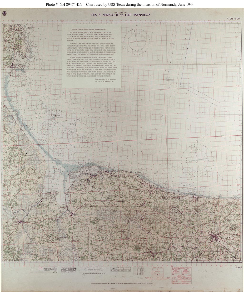
Photo #: NH 89474-KN (color) -- Extended Caption

Normandy Invasion, June 1944

Chart of the invasion area used by USS Texas (BB-35) during her bombardments in support of the landings on 6 June 1944.
"Utah" Beach is at left, with "Omaha" Beach along the lower shoreline. Parallel lines in the chart's upper right section mark channels swept for enemy mines.
See below for the text contained in the upper left center.

Donation of Captain R.B. Derickson, USN (Retired), who was Texas' Gunnery Officer during the invasion.

U.S. Naval Historical Center Photograph.

Online Image: 303KB; 1025 x 1225 pixels


The following text is provided in the upper left portion of this chart:

"USS Texas' Gunfire Support Chart for Normandy Landing"

"This British Admiralty chart is one of many prepared early in 1944 for the invasion of France. It was issued to and continually used by Cdr. R.B. Derickson, USN, Gunnery Officer in USS Texas, in preparation and execution of her shore bombardment missions supporting landings in the Omaha Beach area."

"The parallel lines marked with dan buoys (small circles) indicate the channels that were swept of mines just before D-Day, 6 June. In the westerly swept channel the positions marked 0130 and 0210 show Texas's positions during the pre-dawn approach to the landing area. Various spots where Texas anchored to provide fire support, observe, or await new assignments are marked by small pencilled circles with anchors, the figures beside indicating dates in June."

"The shore bombardment annex to the operation plan designated targets scheduled for fire and other likely ones, indicated on the chart by letter 'T' (Texas) and a serial number such as 'T1' in grid position 586939 slightly back of the cliffs of Pointe du Hoc. This was a well protected German battery commanding the approaches, fire support and transport areas, and the boat lanes to the beach. Consequently it was Texas' first and primary main battery target on opening fire at 0600, and was silenced in short order. Successive positions of the Allied line of advance are shown by wavy pencilled lines whose ends are marked by small circles and pennants. These lines were drawn in order to see whether designated targets were ahead or behind the Allied front lines."

"Donated by Capt. R.B. Derickson,
USN(Ret.), of Annapolis, Md."


Note by Naval Historical Center staff: The battery at Pointe du Hoc, described above, was not actually in place during the "D-Day" invasion, though all intelligence indicated that it was there, and that it would (as the text above states) seriously endanger the landing area. It was accordingly the subject of heavy air and sea bombardment, as well as of a courageous assault by U.S. Army Rangers. See Samuel Eliot Morison: "The Invasion of France and Germany" 1944-1945, Part I-VII-4 "Approach to Omaha, 6 June 1944 ... The Rangers at Pointe du Hoc"

Click on the small photograph to prompt a larger view of the same image.

If you want higher resolution reproductions than this digital image, see: "How to Obtain Photographic Reproductions."

Return to Naval Historical Center home page.

18 December 2003